What's New? The BPDA GIS Department has made many changes to make it easier for neighbors and makers of all kinds to collaborate on the improvement, extension and applications of the city's representation of itself. Click here to read more about it!.
Data Download
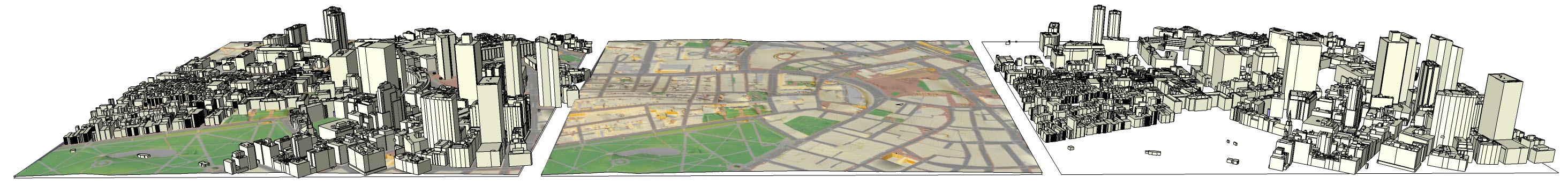
The Boston Planning and Development Agency (BPDA) maintains a 3D model of the city as a visualization and analytical tool for understanding ideas related to the future of neighborhoods. To explore the city model in an interactive fly-through, click here. The BPDA shares the detailed city-wide model in formats intended to facilitate collaboration between diverse communities who have an interest in understanding places in the city as they have changed or as they may be changed.
Tiled City Model Components
Click the blue info-dots  , for information and tips for using each of the of the model components.
| ||
| Sketchup Model |
Terrain with groundplan in OBJ format |
Building Model Collection in .OBJ format |

| ||
| Base Maps: JPG |
2021 Orthophoto JPEG |
DXF Base Layers |
To make it easier for users of 3D modeling tools to acquire complete 3D model covering specific area of interest, model components are packaged using a system of 5,000 foot square tiles that snap together seamlessly. Each of the city-model components is made available in open-source data formats, and as an all-in-one SketchUp format model that combines all of the components in one model per tile that can be imported with into most commercial modeling tools.
See the links at the bottom of this page to download seamless city-wide layers.
Click the Map to Download Tiled Model Resources
This is a demonstration page: Tile I-3 is the only tile that actually link to resources
City-Wide Seamless Data-Sets
- Latest City-Wide Building Model Collection: Esri Geodatabase
Issued August 30 2021
- City-Wide Model Catalog in CSV Format
Issued August 30 2021
- Tile Grid Resources
- City-Model components published by the BPDA Urban Design Technology Group. Includes 2D CAD and 3D model files organized by Boston neighborhoods.
- Additional 2D GIS Data is available through the City of Boston's GIS Data Hub.